RIVHAB PLLC: Your Trusted Engineering Partner for mapping an

Advanced Technology
Better Data leads to Better Design
Better Data leads to Better Design
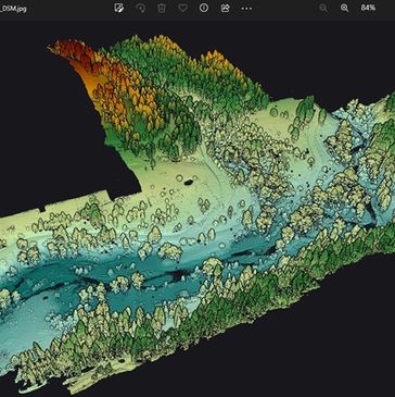
Our state-of-the-art technology and software solutions provide accurate terrain mapping and survey-grade control. The premier of our drone fleet is our LiDAR drone, that can capture data points beneath the thickest vegetation.

Better Data leads to Better Design
Better Data leads to Better Design
Better Data leads to Better Design
Our technology allows more accurate elevations. Having accurate elevations and terrain models leads to the most accurate hydraulic models. Less error means better designs.

Advanced Technical Skills
Better Data leads to Better Design
Advanced Technical Skills
Obtaining precise elevations is critical to ensure successful revegetation. Without accurate data and precision in water surface elevations, a new wetland like the one shown above wouldn't survive. Our experienced engineers are perfectionists when it comes to our final design accurace.
The LiDAR Advantage
We are excited about the huge advantage our in-house LiDAR brings to our designs!! We eliminate expensive survey crews and subcontracting by having the technology and pilots on staff. Our technology captures ground points through the thickest tree canopy to provide accurate bare earth terrain. The BEST designs use the BEST data!! Contact us at info@rivhab.net to learn more and improve your hydraulic model accuracy.
Federal Certifications
8(a), WOSB, EDWOSB


RIVHAB, PLLC
485 E Riverside Drive, Suite 300, Eagle, ID 83616; info@rivhab.net
Copyright © 2019 RIVHAB PLLC - All Rights Reserved. Photos illustrate previous experience.